
Drone Mapping
Home >> Drone Mapping
Professional Drone Mapping in Birmingham, AL, Atlanta, GA & Nashville, TN
Drone mapping has nowadays become an essential tool for many industries. From construction sites to agricultural fields, drones provide a unique perspective that allows for precise and efficient mapping. The use of drones for mapping is especially beneficial as it offers high-quality results in less time than traditional methods. At AirBee, we offer reliable drone mapping services that help you get the most accurate data for your projects.

The Benefits of Drone Mapping
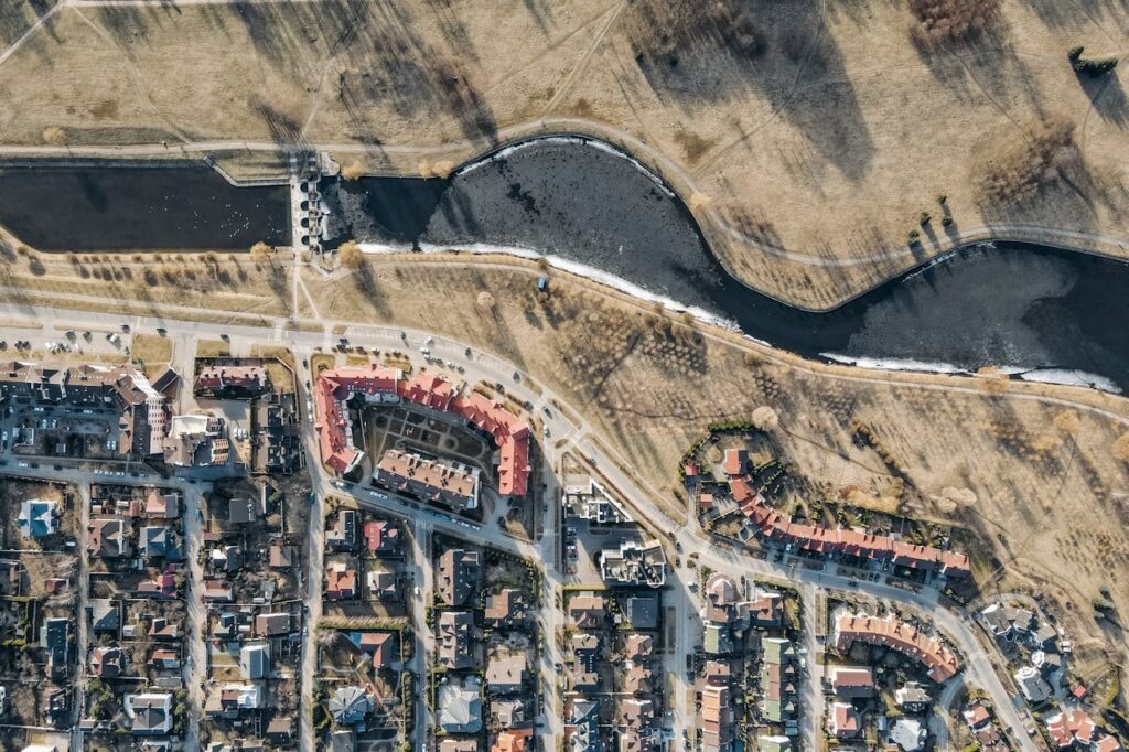
Drone mapping has transformed how businesses approach surveying and data collection. Using drones, it’s possible to gather vast amounts of data quickly, efficiently, and without the need for costly and time-consuming manual processes. Whether it's a large construction site, a real estate project, or an agricultural plot, drones make it possible to create high-resolution maps and models from above.
For businesses in industries like construction, mining, agriculture, and land surveying, aerial drone mapping offers the benefit of real-time data and precise measurements. Drones equipped with high-end cameras and sensors capture detailed images, which can then be stitched together to create accurate topographic maps, 3D models, and digital surface models.
How 3D Drone Mapping Works
3D drone mapping is a powerful tool that uses a drone’s high-resolution cameras and software to create three-dimensional models of the land. By flying over the target area, the drone captures multiple images from various angles. These images are then processed using specialized software to create a 3D model, which provides valuable insights for projects that require precise measurements and topographical details.
This technology is especially useful for industries such as construction, urban planning, and agriculture, where accurate, detailed maps and models are essential for project planning and monitoring. 3D drone mapping helps professionals make informed decisions, minimize risks, and save time and resources.
Why Choose Our Drone Mapping Services in Birmingham, AL, Atlanta, GA, and Nashville, TN?
Traditional mapping methods like ground surveys can be slow, expensive, and labor-intensive. In contrast, drone mapping services offer a more efficient and cost-effective way to gather data. Drones can cover large areas in a short amount of time, collecting high-quality images that are later processed into comprehensive, accurate maps.
For real-time data, aerial mapping surveys are a great solution. Whether you’re working on a construction site, evaluating agricultural land, or conducting environmental studies, drones provide the precise data you need for a fraction of the cost and time of traditional methods.
Serving Clients Locally and Beyond
If you’re searching for drone mapping near me, AirBee offers drone mapping services in Birmingham, AL, Atlanta, GA and Nashville, TN. We extend our expertise to drone mapping in Birmingham, AL and various other locations like Atlanta, ensuring that clients receive fast, reliable mapping services wherever they are. Our team is equipped with state-of-the-art drones and technology to handle mapping projects of all sizes and complexities.
Whether you’re managing a real estate project, surveying land, or gathering data for agricultural purposes, our drones provide high-quality imagery that gives you the insights you need for your project’s success. With our professional services, you can expect fast turnaround times and highly accurate results.
From urban planning to agriculture, aerial mapping surveys offer significant benefits across various industries. For real estate developers, drones allow you to survey large plots of land, helping you better understand the area and make informed decisions. Similarly, farmers can use aerial mapping to monitor crop health and improve yield predictions. Construction companies can track the progress of a site over time, ensuring the project stays on schedule.
In each case, drone mapping provides valuable data that traditional surveying methods can’t match, helping companies stay ahead in their respective fields.
Get Started with Professional Drone Mapping in Birmingham, AL and Atlanta, GA Today
Don’t miss out on the benefits of drone mapping. Whether it’s for construction, real estate, or any other field, we are ready to assist you. Get in touch now for expert drone mapping in in Birmingham, AL, Atlanta, GA and Nashville, TN!

FAQs
Drone mapping is the process of using drones to capture high-resolution images and other data from above. These images are then processed to create maps, models, or other digital products for various industries.
3D mapping is used in various fields, including construction, real estate, agriculture, and environmental monitoring. It helps create detailed models of landscapes and structures, which can be analyzed for better decision-making.
Aerial surveying and mapping involve the use of drones or aircraft to collect data about the earth’s surface. This data is then used to create maps, models, and surveys for various purposes, such as land development, environmental monitoring, and infrastructure planning.
The purpose of an aerial map is to provide a comprehensive view of a specific area from above. This allows for more detailed analysis and planning, making it an essential tool in fields like construction, agriculture, and urban development.
Drones equipped with high-resolution cameras and advanced GPS systems are ideal for 3D drone mapping. Popular models for this purpose include the DJI Phantom 4 RTK, Matrice 300 RTK, and the senseFly eBee X.
The cost of drone mapping varies depending on the size of the area being surveyed, the complexity of the project, and the type of data needed. Generally, it is more affordable than traditional surveying methods due to the efficiency and speed of drone technology.